
High Arctic Expedition: Where Art Meets Land 2028

date_range
14 days from

£9469 GBP pp

* Current p/p indicative rate.

Overview
Highlights
Dates & Prices
Itinerary
Map
Ships

Highlights

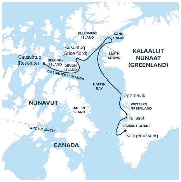
  • Explore Greenland and the Canadian High Arctic – Journey from Ilulissat and Upernavik to Smith Sound, Kane Basin, Ellesmere Island, Devon Island and Tallurutiup Imanga, travelling through vast landscapes of glaciers, ice and Arctic wilderness.
  • Experience exceptional Arctic wildlife and landscapes – Discover iceberg-filled waters, fjords and remote islands, with opportunities to encounter whales and other High Arctic wildlife amid the endless summer light.
  • Discover Inuit culture, art and Arctic history – Gain insights into Inuit knowledge, culture and contemporary artistic perspectives, while visiting communities and historic sites including Beechey Island, associated with the Franklin expedition.
Capacity: 80, Types: ExpeditionSingle cabins
Feture image for High Arctic Expedition: Where Art Meets Land 2028

Journey through Greenland and the Canadian High Arctic, where glaciers, shifting ice, wildlife, and endless summer light have inspired generations of artists and travellers. In partnership with the McMichael Canadian Art Collection, explore how art shapes perceptions of the North while Inuit artists and cultural voices reveal a living homeland known through place, memory, and knowledge. From Sarvarjuaq/Pikialasorsuaq to Ellesmere Island and Devon Island, encounter landscapes whose scale and vitality no single image can contain in all its living complexity.

  • Explore Greenland and the Canadian High Arctic – Journey from Ilulissat and Upernavik to Smith Sound, Kane Basin, Ellesmere Island, Devon Island and Tallurutiup Imanga, travelling through vast landscapes of glaciers, ice and Arctic wilderness.
  • Experience exceptional Arctic wildlife and landscapes – Discover iceberg-filled waters, fjords and remote islands, with opportunities to encounter whales and other High Arctic wildlife amid the endless summer light.
  • Discover Inuit culture, art and Arctic history – Gain insights into Inuit knowledge, culture and contemporary artistic perspectives, while visiting communities and historic sites including Beechey Island, associated with the Franklin expedition.

Availability is always subject to confirmation. Please check with us before booking flights

09 August, 2028 to 22 August, 2028 on Ocean Nova
Prices

Prices quoted here are often dependent on currency fluctuations. Please check with (01432 507450 or info@small-cruise-ships.com) for the very latest price, which may well be cheaper than the one advertised here.
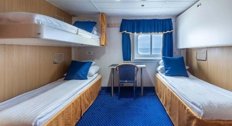
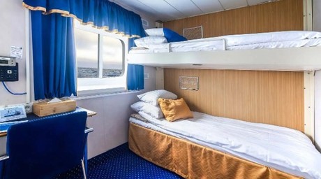
Cabin Category 1
£9469 GBP pp
Cabin Category 1
Triple Upper Deck
Cabin Category 2
£11009 GBP pp
Cabin Category 2
Bunk Bed Twin Upper Deck
Cabin Category 3
£11935 GBP pp
Cabin Category 3
Upper Deck Twin Upper Deck
Cabin Category 4
£12549 GBP pp
Cabin Category 4
Bridge Deck Twin Bridge Deck
Cabin Category 5
£13319 GBP pp
Cabin Category 5
Superior Twin Upper Deck
Cabin Category 6
£17945 GBP pp
Cabin Category 6
Single Upper Deck
03 September, 2028 to 16 September, 2028 on Ocean Nova (reverse)
Prices

Prices quoted here are often dependent on currency fluctuations. Please check with (01432 507450 or info@small-cruise-ships.com) for the very latest price, which may well be cheaper than the one advertised here.
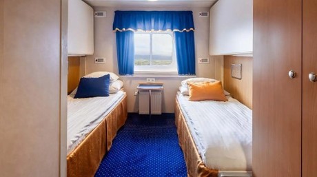
Cabin Category 1
£9469 GBP pp
Cabin Category 1
Triple Upper Deck
Cabin Category 2
£11009 GBP pp
Cabin Category 2
Bunk Bed Twin Upper Deck
Cabin Category 3
£11935 GBP pp
Cabin Category 3
Upper Deck Twin Upper Deck
Cabin Category 4
£12549 GBP pp
Cabin Category 4
Bridge Deck Twin Bridge Deck
Cabin Category 5
£13319 GBP pp
Cabin Category 5
Superior Twin Upper Deck
Cabin Category 6
£17945 GBP pp
Cabin Category 6
Single Upper Deck
show reverse itinerary
Day 1: Kangerlussuaq, Greenland - Cross the Arctic Circle

Arrive by charter flight in Kangerlussuaq, whose Kalaallisut name means “big fjord.” The community developed around an American airbase established during the Second World War, its sheltered inland setting chosen for comparatively stable flying conditions. From here, transfer by Zodiac to your expedition vessel and prepare to follow the fjord toward the sea.

Kangerlussuaq Fjord carries the journey westward through a landscape shaped by ice and meltwater. Rounded mountains rise above broad glacial valleys, while suspended sediment lends the shallows a milky turquoise colour. As the long waterway opens gradually toward Davis Strait, cross the Arctic Circle and leave the continental interior behind. The transition from land to fjord to open sea marks a fitting beginning to the northern passage ahead. 

Day 2: Sisimiut Coast - Greenland’s Rugged Western Shore

Cruise along the dramatic Sisimiut coast, where mountains rise sharply from the sea and small settlements cling to the shoreline. This region reflects Greenland’s seafaring traditions, with communities deeply tied to land and water. As you sail, shifting light continually redraws the jagged peaks, revealing new textures, colours, and contours along the coast.

Day 3: Ilulissat - Where Icebergs are Born

Ilulissat means “icebergs,” a fitting name for a city beside one of the world’s great moving ice systems. At the head of the UNESCO-listed Ilulissat Icefjord, Sermeq Kujalleq ranks among the fastest and most active glaciers on Earth. Its immense icebergs travel slowly through the fjord before entering Disko Bay, continually transforming the seascape.

The icefjord has shaped human life here for more than four thousand years. That relationship continues in contemporary Ilulissat, a lively Greenlandic city where fishing boats crowd the harbour and the streets bustle with residents and travellers. Restaurants showcase Greenlandic ingredients, while cafés, shops, and the striking Ilulissat Icefjord Centre reflect the city’s growing cultural and creative energy.

Here, deep human history, vibrant city life, and constant environmental change come together at the edge of the ice.

Day 4: Western Greenland - Cathedrals of Ice

Sail among towering glaciers and drifting bergs, each one a shifting sculpture in white and blue. Fjords echo with the sound of calving ice, and mountains rise sheer above waters crowded with floes. Immense, elemental, and constantly changing, this landscape invites you to consider how something so vast and dynamic can ever be captured in paint, photography, or words.

Day 5: Upernavik - Life Among a Thousand Islands

Greenland’s coast breaks apart here into a vast maze of islands, narrow channels, and drifting ice. Upernavik, meaning “the springtime place,” rises from this intricate seascape in a bright sweep of colourful houses and a working harbour.

Fishing and hunting remain central to life across the archipelago, connecting Upernavik with the smaller communities scattered along the coast. Its historic quarter forms the world’s northernmost open-air museum, preserving the church, trading buildings, boats, and tools of an earlier era. Surrounded by rock, sea, and ice, Upernavik reveals the remarkable character of life along Greenland’s northern coast.

Day 6: At Sea - Northward Through Melville Bay

Continue north through Melville Bay, following Greenland’s coast toward Smith Sound. Icebergs drift through these waters in an ever-changing procession, while distant mountains, seabirds, and the possibility of marine wildlife keep attention fixed beyond the decks.

A day aboard creates time to look more closely at the region unfolding around us. Presentations, workshops, and informal conversations with educators explore the wildlife, geography, history, and living cultures of the High Arctic. Between sessions, the decks and observation spaces invite shared discoveries as the journey presses steadily north.

Day 7–8: Smith Sound - Gateway to the Great Upwelling

Venture through Smith Sound, the dramatic channel connecting Baffin Bay with Kane Basin and part of the greater Pikialasorsuaq region. Pikialasorsuaq means “great upwelling” in Kalaallisut and is known in Nunavut as Sarvarjuaq.

Recurring open water within the surrounding sea ice makes this the Arctic’s largest polynya and one of the most biologically productive regions north of the Arctic Circle. Nutrient-rich waters sustain an extraordinary abundance of life, drawing whales, seals, and millions of seabirds to this vital Arctic ecosystem. 

Day 9: Kane Basin - Where Continents Nearly Touch

Sail into Kane Basin, where Ellesmere Island and Greenland nearly meet. Glaciers tower above drifting sea ice, and the shifting Arctic light continually transforms the passage. Long travelled by Inuit, these waters later became a route for expeditions seeking both the lost Franklin expedition and a way to the North Pole. The basin bears the name of American explorer Elisha Kent Kane, who crossed it in 1854 during his search for Franklin. 

Day 10: Ellesmere Island, NU, Canada - Mountains at the Edge of the World

Explore the rugged coastline of Ellesmere, Canada’s northernmost island. Towering mountains, vast ice caps, and deep fjords define a landscape of extraordinary scale. Here, the High Arctic exceeds the images that first inspired us, revealing a world more intricate, dynamic, and alive than any single representation can capture.

Day 11: Ausuittuq (Grise Fiord) - Life in the Place That Never Thaws

Set between the mountains of southern Ellesmere Island and the waters of Jones Sound, Ausuittuq (Grise Fiord) is Canada’s northernmost civilian community. Its Inuktitut name means “the place that never thaws,” a reference to the enduring ice above the community.

Ausuittuq was established through the High Arctic Relocations of 1953 and 1955, when the Canadian government moved Inuit families from Inukjuak and Mittimatalik, in part to reinforce Canadian sovereignty. The hardship and injustice of that history remain part of the community’s story, commemorated by a monument overlooking the shore. Today, family, language, harvesting, and community life give this small and remarkable Inuit hamlet its enduring character.

Day 12: Tallurutiup Imanga (Lancaster Sound) & Devon Island - Whales, Ice, and Vast Horizons

Sail through Tallurutiup Imanga, one of Canada’s largest marine protected areas, alive with whales, seals, and seabirds. Beneath towering cliffs and drifting ice, the sea glimmers with shifting light. Step ashore on Devon Island, the world’s largest uninhabited island, where glaciers meet the sea and tundra unfolds in broad, glacial valleys. Here, light and silence create their own compositions, inviting stillness, reflection, and a deep sense of the Arctic’s living beauty. 

Day 13: Beechey Island - In the Wake of Franklin

Beechey Island holds one of the most tangible chapters in the Franklin mystery. HMS Erebus and HMS Terror spent the winter of 1845–46 here before sailing south and disappearing. The graves of three crew members, remains of the winter camp, stone cairns, and traces left by later search expeditions still mark its narrow, windswept shore.

Protected as part of Beechey Island Sites National Historic Site, these remains capture the expedition at the threshold of mystery. The island later became a base for the vast search effort that helped map much of the Canadian Arctic Archipelago. Inuit testimony proved essential to tracing the expedition’s final movements and, generations later, locating its lost ships. Beechey Island connects Franklin’s failed voyage with its wider legacy, including expanded geographical knowledge, growing colonial ambitions, and an increasingly sustained southern presence in Inuit homelands. 

Day 14: Qausuittuq (Resolute), NU, Canada - At a Crossroads of the High Arctic

Set among the gravel plains and raised beaches of Cornwallis Island, Qausuittuq occupies a strategic place within the waterways of the Canadian High Arctic. Its Inuktitut name means “place with no dawn,” a reference to the long polar night, while the summer season brings light that lingers around the clock.

The modern community began with the Canadian government’s High Arctic Relocation of 1953. The Qausuitturmiut who call it home have built a distinct community that now serves as an important centre for northern research, transportation, and expedition travel.

Disembark in Qausuittuq and transfer to the airport for the charter flight to Ottawa. Here, at a historic crossroads of Inuit travel, Arctic exploration, and contemporary northern life, the sea journey ends and the route turns south. 

Please note:

Published itineraries reflect our intended route and experiences but cannot be guaranteed. Weather, sea and ice conditions, government regulations, operational considerations, wildlife, and other circumstances may require changes to the planned schedule. Visits to specific communities also depend on local conditions and the needs, availability, and requests of the communities themselves. When changes are necessary, we will seek the best available alternatives, including another community visit where circumstances allow.

Itinerary also available in reverse
Ocean Nova
The ice-strengthened 73 metre long expedition ship Ocean Nova was built in Denmark in 1992 with high ice class to serve Greenland’s west coast. In 2004 to 2005 she was completely refurbished an…

Ocean Nova

Ice Class: Ice 1B, E0 (Hull Ice 1A)
Cabins 37

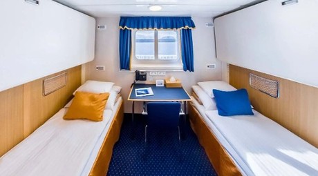
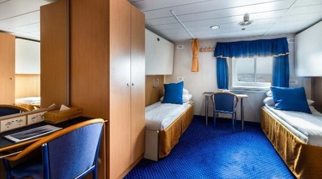
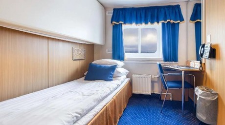
The ice-strengthened 73 metre long expedition ship Ocean Nova was built in Denmark in 1992 with high ice class to serve Greenland’s west coast. In 2004 to 2005 she was completely refurbished and has now a career as a small and comfortable expedition ship. The Ocean Nova can accommodate 86 passengers (but is often limited to 65 - 80 for some cruises) in single, double and triple cabins, all with sea-view and private facilities. The double cabins have either twin beds. The triple cabins have upper and lower beds. In your cabin you will also find a desk with chair and ample storage space for clothes and equipment.

In the dining room you are treated to delicious meals in between landings and in the panorama lounge you can enjoy a drink with a breathtaking view of the surrounding polar landscape. This is where on board specialists entertain and educate you with lectures on polar biology, history, geology and conservation. There is also a library with panoramic views and a good selection of polar books. On board there is a satellite phone, gym and medical doctor. Passengers are welcome on the bridge around the clock and there is always something to see or search for from the spacious observation decks. The ship has North European officers and there is a friendly and informal atmosphere on board. Travelling with this small expedition ship offers an entirely different experience and perspective than you can get on a larger and more conventional cruise ship.

Cabins are spread over two decks and include cabins for the single traveller, double and triple cabins, all with sea-view and private facilities. The comfortable dining room located on the Upper deck seats all passengers in a single sitting and offers delicious meals with a mixture of table service and buffet. The informal dining arrangement adds to the friendly atmosphere onboard and meals are a great chance to discuss all you have seen with your fellow travellers, and for the expedition team to share their knowledge. 

With one of the highest ice classes (1B) and a 2000 hp diesel engine, Ocean Nova is a small but sturdy expedition vessel just as at home in the icy waters of Svalbard as she is in a tranquil Scottish loch. The ship has a crew of 34, including North European officers, whose prime concern is your safety as well as ensuring wildlife sightings and weather conditions are maximised. For your safety there are two fully enclosed lifeboats and a medical clinic onboard.


Deck plans are for illustrative purposes only – The actual ship and cabin layout may differ.

Cabin layout for Ocean Nova
Overview
Highlights
Dates & Prices
Itinerary
Map
Ship

14 days from £9469 GBP pp

Find your favorite region